
All-band RTK GNSS receiver. Ultimate precision, even in the most challenging conditions.
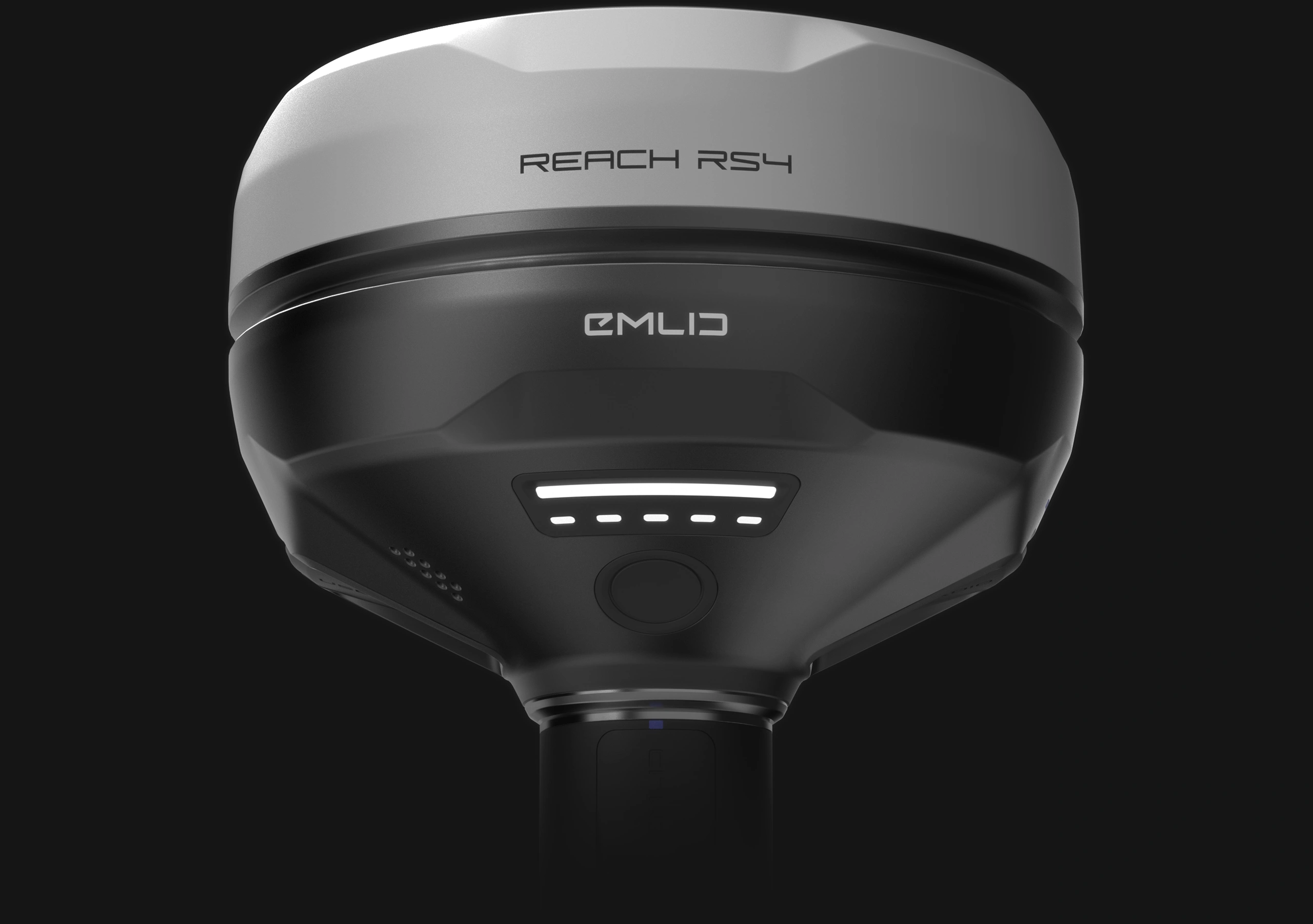
Reach RS4 RTK GNSS Receiver. High-accuracy, even under canopy
The Reach RS4 can track all available satellite constellations and frequencies, including the lower L5 and L6 bands, which are more resistant to multipath and interference. With 672 channels, it can track 40+ satellites at a time. These features ensure reliable performance and centimeter-level precision


Next-gen tilt compensation
The Reach RS4 delivers accurate results even at high tilt angles — for example, a 30° tilt still achieves 18 mm precision.1 The compensation mechanism activates with just a few moves and remains stable throughout the survey, saving time and avoiding the need for recalibration.


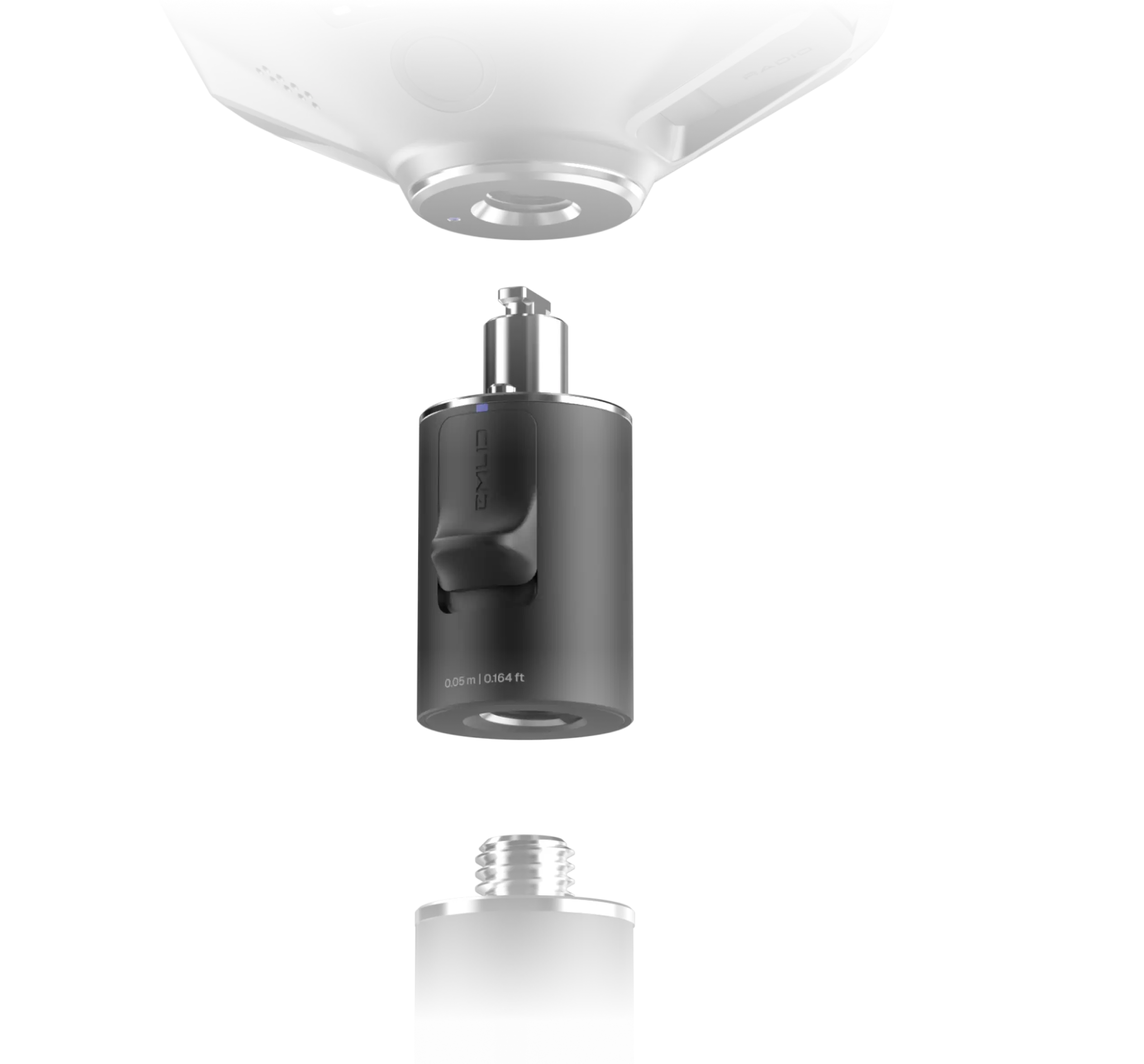
Quick release mount
This mount is specifically designed for tilt compensation, eliminating backlash and securing the receiver firmly to the survey pole. Even a small amount of wobble between the device and the pole can compromise the accuracy when tilting. The quick-release system provides a fast and reliable connection for maximum precision.
Base and rover
NTRIP
Work in RTK with VRS or a single baseline CORS network in RTCM3 format. You can also connect another GNSS receiver as an NTRIP base using Emlid NTRIP Caster
Dual-band radio
UHF 450 MHz

LoRa 915 MHz
Built to perform in extreme conditions
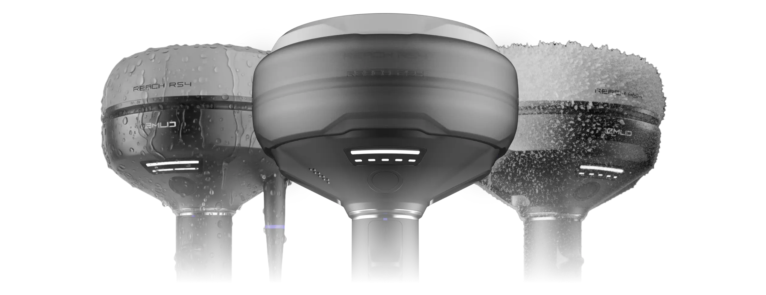

Magnesium alloy body

16 hours on one charge

Waterproof

-40 to +65 ºС
Not sure which receiver fits your workflow?
Share a few details, and our Sales Engineers will help you pick the right gear for the job.
.webp)
First reviews


Software for every stage of your project
The Reach RS4 comes with Emlid Flow, a comprehensive mobile and cloud solution compatible with both iOS and Android. It keeps your team aligned and your projects on track while supporting various site tasks.
Coordinate your team


Execute projects on site


Specification
Mechanical
- Dimensions 128.6 x 128.6 x 99.3 mm
- Weight 927 g (2.04 lb)
- Operating temperatures -40 to +65 °C
- Ingress protection IP68
Electrical
- Autonomy 16 hrs as RTK rover with tilt
-
Battery Li-Ion 5000 mAh, 7.2 V
36 Wh -
Charging USB Type-C (PD): 5V—3A
9V—3A, 12V—3A, 15V—3A
Positioning
-
Static H: 4 mm + 0.5 ppm
V: 8 mm + 1 ppm -
PPK H: 5 mm + 0.5 ppm
V: 10 mm + 1 ppm -
RTK H: 7 mm + 1 ppm
V: 14 mm + 1 ppm - Tilt compensation RTK + 2 mm + 0.3 mm/°
- Convergence time ~5 s typically
Connectivity
-
Lora radio
Frequency range
ㅤ
Power
Distance
868/915 MHz
Up to 1W
Up to 8 km UHF radioFrequency range
ㅤ
Power
Protocols
Modulation type
410–470 MHz
Up to 2W
TRIMTALK 450S**
GMSK -
LTE modem
Regions
Bands Global
FDD-LTE: 1, 2, 3, 4, 5,
7, 8, 12, 13,
18, 19, 20, 26, 28
TD-LTE: 38, 39, 40, 41
UMTS (UHPS/FDD):
1, 2, 5, 8
Quad-band, 850/1900
900/1800 MHz SIM card Nano-SIM -
LTE modem
Regions
Bands Global
FDD-LTE: 1, 2, 3, 4, 5,
7, 8, 12, 13,
18, 19, 20, 26, 28
TD-LTE: 38, 39, 40, 41
UMTS (UHPS/FDD):
1, 2, 5, 8
Quad-band, 850/1900
900/1800 MHz SIM card Nano-SIM - Wi-Fi 802.11a/b/g/n
- Bluetooth 5.1 (BR/EDR + LE)
- Ports RS-232, USB Type-C
- *Use the correct antenna, LoRa or UHF, for your setup. **TRIMTALK is a trademark of Trimble Inc.
Data
- Corrections NTRIP, RTCM3
- Position output NMEA, LLH/XYZ
- Data logging RINEX, NMEA, LLH/XYZ, UBX
- Internal storage 16 GB
GNSS
-
Signal tracked GPS: L1C/A, L2C, L5,
GLONASS: L1OF, L2OF,
Galileo: E1-B/C, E5a, E6,
BeiDou: B1I, B1C, B2a, B3I,
QZSS: L1C/A, L1C/B11, L2C, L5,
NavIC: L1-SPS Data, L5-SPS - Number of channels 672
- Update rates up to 10 Hz
Free lifetime support

Community

Expert assistance
Buy your Reach RS4 today
Reach RS4
Reach RS4, Case, USB-C cable

$3,899
Emlid Base and Rover Kit
Reach RS4, Reach RS4 Pro, 2x Quick release adapter, Reach RS4 bumper, Reach RS4 Pro bumper

$8,870
Would you like to receive release updates about shipping dates and special offers?
Have a question?
Ask our team
Fill in the contact form, and we will reply within a working day (9:00-18:00 CET).
Direct Dial: +1 817 865 3334 (ex. 101)
Alternatively, you can text us here:
FAQ
What makes the Reach RS4 a top receiver for RTK survey work?
The Reach RS4 is an all-frequency GNSS receiver designed for professional RTK survey and mapping tasks. It works with every major GNSS constellations, including GPS, GLONASS, Galileo and BeiDou to deliver an accurate position. Its powerful antenna and built-in GNSS IMU maintain strong signal reception and orientation in challenging environments such as forests or urban canyons. This GNSS device is manufactured by Emlid company to provide high precision and highly accurate results for geospatial and navigation projects.
Does Reach RS4 come with a software?
Yes! The Reach RS4 comes with Emlid Flow and Emlid Flow 360, mobile and cloud app for Reach GNSS receivers. Emlid Flow simplifies project setup, RTK GNSS receiver, base station and correction service configuration, while Emlid Flow 360 offers smooth synchronization of data between the field and the office. In Emlid Flow, you can also record RINEX for PPK workflows.
How can Reach RS4 integrate with other devices?
The RS4 is designed for flexible integration in professional workflows. It can serve as an RTK base station or GNSS base station, broadcasting correction data to UAV, drone, tractor, or GPR systems for real-time kinematic guidance. When used as a rover, it connects to external equipment through its robust connector interfaces, data cables, or Bluetooth, delivering a position stream directly to controllers or autopilots. Its solid enclosure, high-performance antenna, and dependable signal reception make it easy to embed into GNSS solutions, PPK setups, and precision agriculture or mapping platforms — ensuring centimeter-level results across demanding environment.
What level of accuracy does Reach RS4 provide?
Reach RS4 delivers accuracy down to centimeter using advanced algorithms with data from NTRIP correction service reference stations or another GNSS device. Its all-band GNSS antenna, inertial sensor (IMU), and powerful antenna give surveyors an accurate position and attitude information even among buildings or dense vegetation.
Unlike a traditional multi-frequency receiver that only works on a limited set of bands, the RS4 is all-frequency, meaning it can receive every available frequency from supported constellations at once.
What industries and jobs is Reach RS4 good for?
The RS4 is versatile GNSS survey equipment built for land surveyors, GIS specialists, engineers, and construction managers who need highly accurate GNSS receivers. It is also ideal for UAV pilots and operators performing aerial mapping or environmental monitoring. Utilities, telecom, and infrastructure teams use it for asset mapping, precise as-built documentation, and inspection tasks. With its rugged enclosure, reliable signal reception, and versatile capabilities, the RS4 delivers centimeter-level accuracy for a wide range of GNSS applications.
Dedicated technical support from the manufacturer ensures smooth deployment and long-term reliability.
1 – The formula is RTK + 2 mm + 0.3 mm/°, where RTK is 7 mm + 1 ppm. Therefore, with a baseline of 1 km, the formula becomes 7 mm + 1 mm + 0.3 mm × 30° = 18 mm
2 - UHF radio supports transmission power up to 2 W. The exact allowable power level depends on local country regulations, and in many cases, may require a license. LoRa radio supports transmission power up to 1 W. The maximum output also varies by country, but LoRa is optimized to remain within license-free limits in most regions.
3 – TRIMTALK is a trademark of Trimble Inc.