REACH RS3
Data collection with centimeter
precision. Made for professionals.
Data collection with centimeter
precision. Made for professionals.
$2,999
Buy
The Reach RS3 is a game changer for my team. The tilt compensation allows accurate surveying of hard to reach points, and building corners and walls can now be shot directly without using offsets. I am amazed at the accuracy, even with fairly large tilts! Emlid has done it again with the RS3, leading the way in affordable, accurate and versatile GNSS survey kit.
Using the RS3 was like using the RS2s for the first time, the opportunities the tilt compensation opened up for us were fantastic. Building corners and walls are now a breeze, also for recording points that are just that bit too far under cover.
If you're in the industry, tilt compensation is something you have to try. Emlid have once again brought this feature within reach for a wide audience, I can't wait to see the creative ways people will start putting this to use on the forums or user groups.

Open-pit mine design
Reach RS2 helped our users design a gold mine pit in Alaska. The team surveyed drill collars with centimeter accuracy and exported the results to a GIS app for pit design. Then they used established base points to place GCPs for progress monitoring.


Open-pit mine design
Reach RS2 helped our users design a gold mine pit in Alaska. The team surveyed drill collars with centimeter accuracy and exported the results to a GIS app for pit design. Then they used established base points to place GCPs for progress monitoring.
Topographic survey on the coastline
Photogrammetry for a maritime concession in Punta Arenas, Chile, was a challenging project for Kenos Drones, requiring advanced GNSS survey equipment. The team used Reach RS2 for RTK land surveying equipment at sub-zero temperatures. They lifted high and low tide lines from the coast of the Strait of Magellan.

Emlid Flow is a mobile app for iOS and Android. It handles all the fieldwork—receiver settings, data collection, coding, linework, and stakeout. All survey data is in sync with the cloud-based service Emlid Flow 360, which allows you to access your projects from your browser and manage survey data and code lists.
Collect points, write detailed descriptions, and perform quality control using our responsive interface. The app has built-in support for projections, grids, and geoids and a library with hundreds of verified coordinate systems.
Emlid Flow has a wizard for manual coordinate system creation for areas without a predefined coordinate system. To start your survey, you just need to specify the datum, enter transformation parameters or projection, and choose your geoid.
Emlid Flow displays East-North and straight-to-line distances and supports cut and fill indication. When you get close to a point, the indication switches to a close-up alignment mode helping you to center exactly above the point.
Additionally, the app serves as a reliable surveying tool with a close-up alignment feature for precise positioning.

Measure and move ahead with just a few taps. You can use either predefined geometry types or a full-blown code library, whatever suits your needs.
Add codes, quickly switch between different object codes, start new lines, and continue collecting existing ones.
Upload your custom code library or use a standard one built into Emlid Flow with more than a hundred codes available from the start.
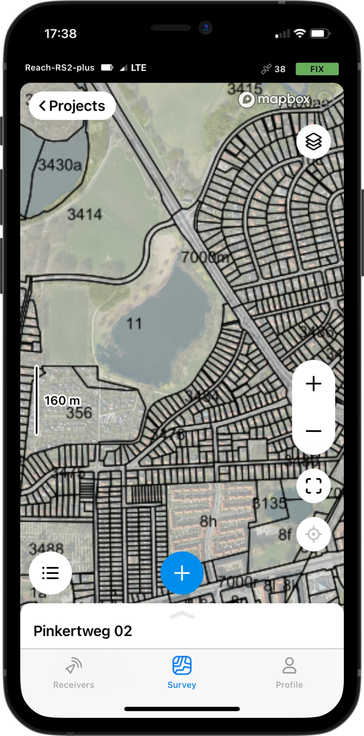
Upload topographic maps, cadastral plans, and aerial imagery from WMS and WMTS sources or work with a built-in satellite map.
Find or adjust missing or outdated local coordinate system parameters. Depending on the data provided, Emlid Flow automatically chooses the calibration algorithm that delivers the best accuracy.
All residuals are placed on a single screen, so you have the full context while you adjust.
Work with survey plans, quickly adjust designs in the field, or simply review data for informed decision making.
Tools allow you to create new geometry directly in the app with specified distance and direction, find coordinate geometry attributes such as area, distance, direction, slope, and more.
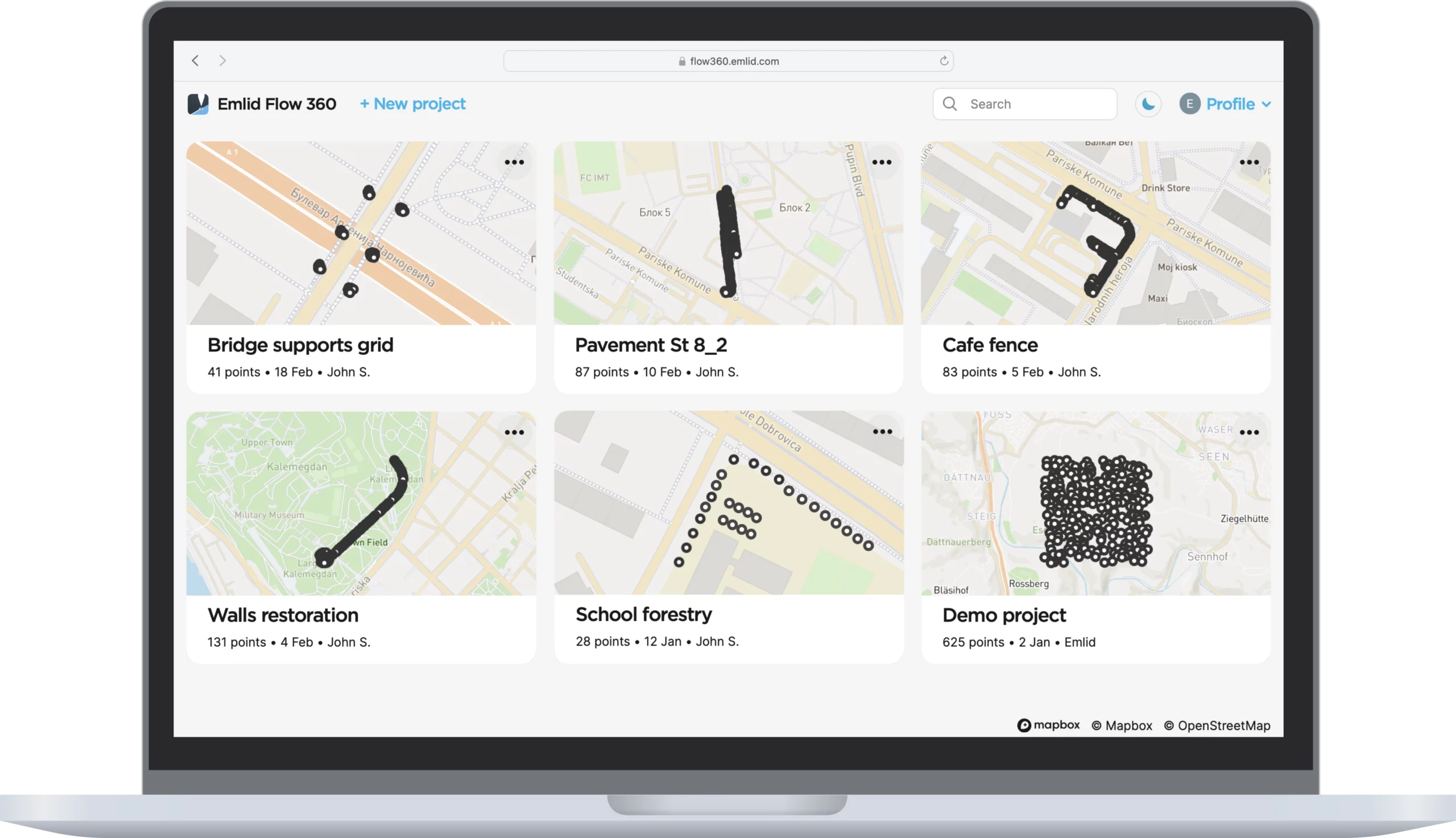
The Emlid Flow app is synchronized with the Emlid Flow 360 service. This allows you to create and access survey projects, manage coordinate systems, and export and import data using both the mobile app and the cloud service at flow360.emlid.com.
CSV, DXF, and Shapefile
The full list of features is available with the Survey subscription.
Try it in Emlid Flow 360 for $25/month.
The basic functions are available with the Free version.
Reach RS3: RTK receiver with tilt compensation
Reach RS3 gets a fixed solution in seconds. The receiver tracks GPS/QZSS, GLONASS, BeiDou, and Galileo. Multi-feed antenna with multipath rejection offers robust performance even in harsh conditions.
Signals tracked
L1OF, L2OF, B1I, B2I, E1-B/C, E5b, L1C/A, L2C
Reach RS3 gets a fixed solution in seconds. The receiver tracks GPS/QZSS, GLONASS, BeiDou, and Galileo. Multi-feed antenna with multipath rejection offers robust performance even in harsh conditions.
Signals tracked
L1OF, L2OF, B1I, B2I, E1-B/C, E5b, L1C/A, L2C

.webp)


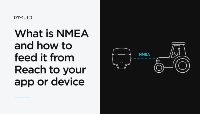
Reach RS3 provides data in standard NMEA that is used by most GIS and survey apps. Simply connect your device to Reach over Bluetooth or via cable, and turn on “Position output” in Emlid Flow.
Enjoy your work with Reach RS3 and any regular data collector. Stream NMEA data via Bluetooth.
We’ve successfully completed the tests with the leading land survey software MicroSurvey FieldGenius. Reach RS3 pairs with most types of traditional data collectors via Bluetooth or USB and feeds the coordinates to MicroSurvey FieldGenius in NMEA format. Check out our FieldGenius Setup guide to get started!
Compatible apps
ArcGIS Field Maps,
FieldGenius, and others
You can control your Reach unit, set up a base station, log RINEX data, configure output — everything in one app.
You can control your Reach unit, set up a base station, log RINEX data, configure output — everything in one app.
With Reach RS3, you can access or broadcast corrections over NTRIP independent of the Internet connection on your device. Reach RS3 features a power-efficient 3.5G HSPA modem with 2G fallback and global coverage. +(1).webp)
Reach RS3 logs industry-standard RINEX files. Enable raw data recording to download and post-process it with popular PPK software. +(1).webp)
Antenna calibration details for Reach RS3 are added to NOAA’s National Geodetic Survey registry. The post-processing will be flawless with OPUS, AusPos, NRCan, and other PPP services. +(1).webp)
-20 to +65 ºС
Working temperature. Isn’t afraid of either heat or cold.
IP67
All connectors are completely sealed and protected from water and dust with silicone plugs.
Up to 22 hours
Industrial LiFePO4 battery can charge over USB from a powerbank.
Polycarbonate body
Polycarbonate body
Polycarbonate, an extremely durable material used in bulletproof glass, makes Reach RS3 impact-resistant.
126 x 126 x 142 mm
Fits in a small bag.
950 g
Weighs less than a typical survey pole.
Richard Mohd, drone pilot, Trinidad and Tobago
Our user applied Reach RS2 during Precise Point Positioning (PPP) survey for a coastal protection project. He set up the unit for 4 hours to determine the base’s accurate coordinates.

Richard Mohd, drone pilot, Trinidad and Tobago
Our user applied Reach RS2 during Precise Point Positioning (PPP) survey for a coastal protection project. He set up the unit for 4 hours to determine the base’s accurate coordinates.
Fermat Topografia, Costa Rica
With Reach RS2, our users defined initial points for future earthworks in Guanacaste, Costa Rica. They then used the initial points as reference points and ran an RTK survey for volume calculations to verify the amount of removed material. Reach RS2 had great reception even in tight spots.
Jaime Martinez, surveyor, Chile
With Reach RS2, the surveyor placed 200 points to establish farmland properties in San Pedro, Chile. He then imported the dataset to Civil AutoCAD to bring the cadastral plan up to date. After that, he placed stakes with centimeter accuracy to mark the boundaries of each plot.
Grzegorz Krukowski, surveyor, Poland
Reach RS2 helped our user conduct a topographical land survey in Northern Poland woods. Even though the terrain was pretty challenging, the surveyor managed to measure points in places where the sky wasn’t quite visible.

Grzegorz Krukowski, surveyor, Poland
Reach RS2 helped our user conduct a topographical land survey in Northern Poland woods. Even though the terrain was pretty challenging, the surveyor managed to measure points in places where the sky wasn’t quite visible.
Brent Wiebe, drafting technician, Canada
Using Reach RS2, Brent Wiebe from Canada placed GCPs for a drone mapping project. When the CAD files were finished, our user imported them to the ReachView app for laying out the project on-site. Ultimately, this helped to approve the construction of a new dairy barn.
Fermat Topografia, Costa Rica
Our users undertook the topographic survey as a part of a floodplain research project. The team used Reach RS2 to determine the deepest areas of the Aranjuez River most likely to be affected by flooding. This dataset helped them create a contour map of potential flood zones.
Vermont Land Integrity, USA
This pair of Reach RS2 was used for a survey in East Montpelier, Vermont. Reach devices are designed to work even in frosty conditions down to -20ºС / -4ºF. These features allowed surveyors to get the job done even in cold weather.

Vermont Land Integrity, USA
This pair of Reach RS2 was used for a survey in East Montpelier, Vermont. Reach devices are designed to work even in frosty conditions down to -20ºС / -4ºF. These features allowed surveyors to get the job done even in cold weather.
Our team of Application Engineers is ready to help you with all issues and questions during setup and ongoing work with Reach RS3. Send us a question via the contact form. For complicated issues, we arrange calls to speak directly with our clients.
The basic features of Emlid Flow are available for free to all Emlid users.
Mechanical
Electrical
Positioning
Connectivity
Frequency range
Power
Distance
Frequency range
Protocols
Modulation type
Data
GNSS
Do you want to receive news from us?
Subscribe to our newsletter.


Fill in the contact form, and we will reply within a working day (9:00-18:00 CET).

Direct Dial: +1 817 865 3334 (ex. 101)
Alternatively, you can text us here:


