All-band RTK GNSS receiver with dual cameras. Visual stakeout and remote point capture for faster and safer work.
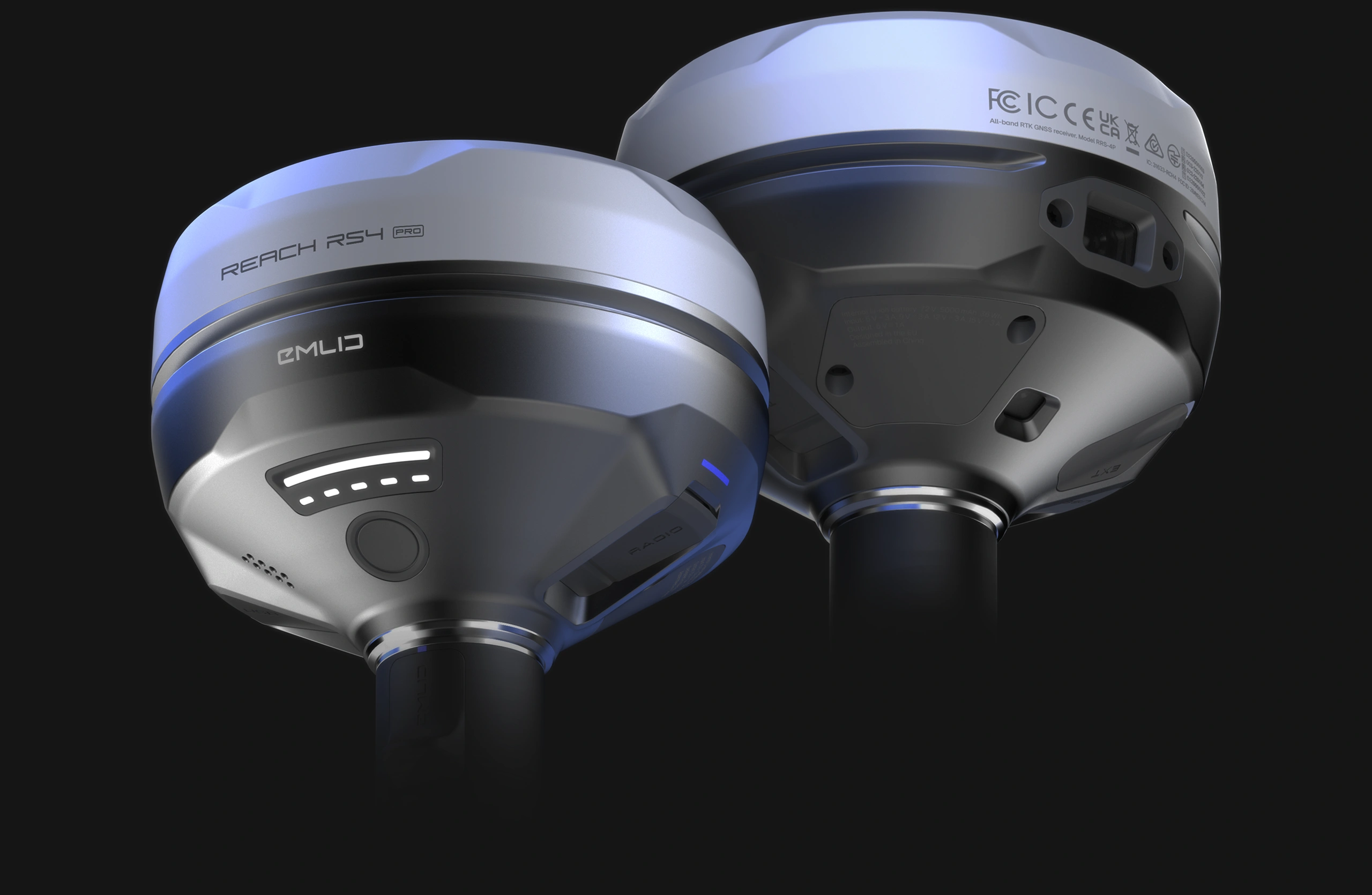
Reach RS4 Pro. Discover the new way to survey with dual cameras
With two Full HD cameras, the RS4 Pro takes surveying and stakeout further than traditional RTK can.
Stake out faster with AR guidance
With the RS4 Pro, stakeout becomes visual. Rather than simply following coordinates on a map, your designs are directly overlaid on the real world, clearly showing where to place stakes.
 Dynamic navigation
 Auto bullseye View
 Cut & fill indicator
 Quick point switch
Crews can work faster with AR guidance, even on complex construction sites and roadworks.
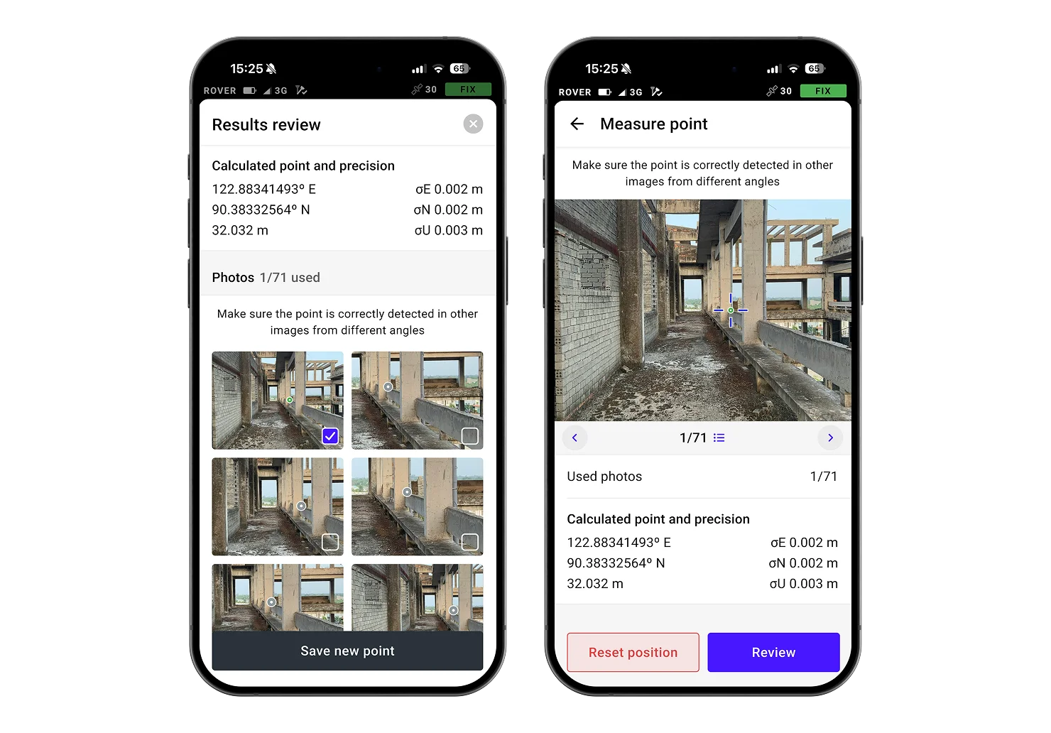
Measure from images
Even if you can't put the pole there, you can still measure it with your RS4 Pro. Use the cameras to measure building facades, areas behind fences, across busy roads and any other inaccessible points.
Save time setting up a total station and avoid hazardous areas.
Unmatched precision, even under canopy
The Reach RS4 Pro delivers centimeter-level accuracy, even in challenging environments like forests or urban canyons. With support for every GNSS constellation and signal frequency, including the L5 and L6 bands, resistant to multipath and interference, the Reach RS4 Pro locks onto 40+ satellites simultaneously using 672 channels.


Next-gen tilt compensation
The advanced tilt compensation stays accurate even at steep angles. For example, at a 30° tilt, the Reach RS4 Pro still delivers 18 mm precision.1 Initialization takes just a few quick movements and remains stable throughout the job—no manual recalibration needed.


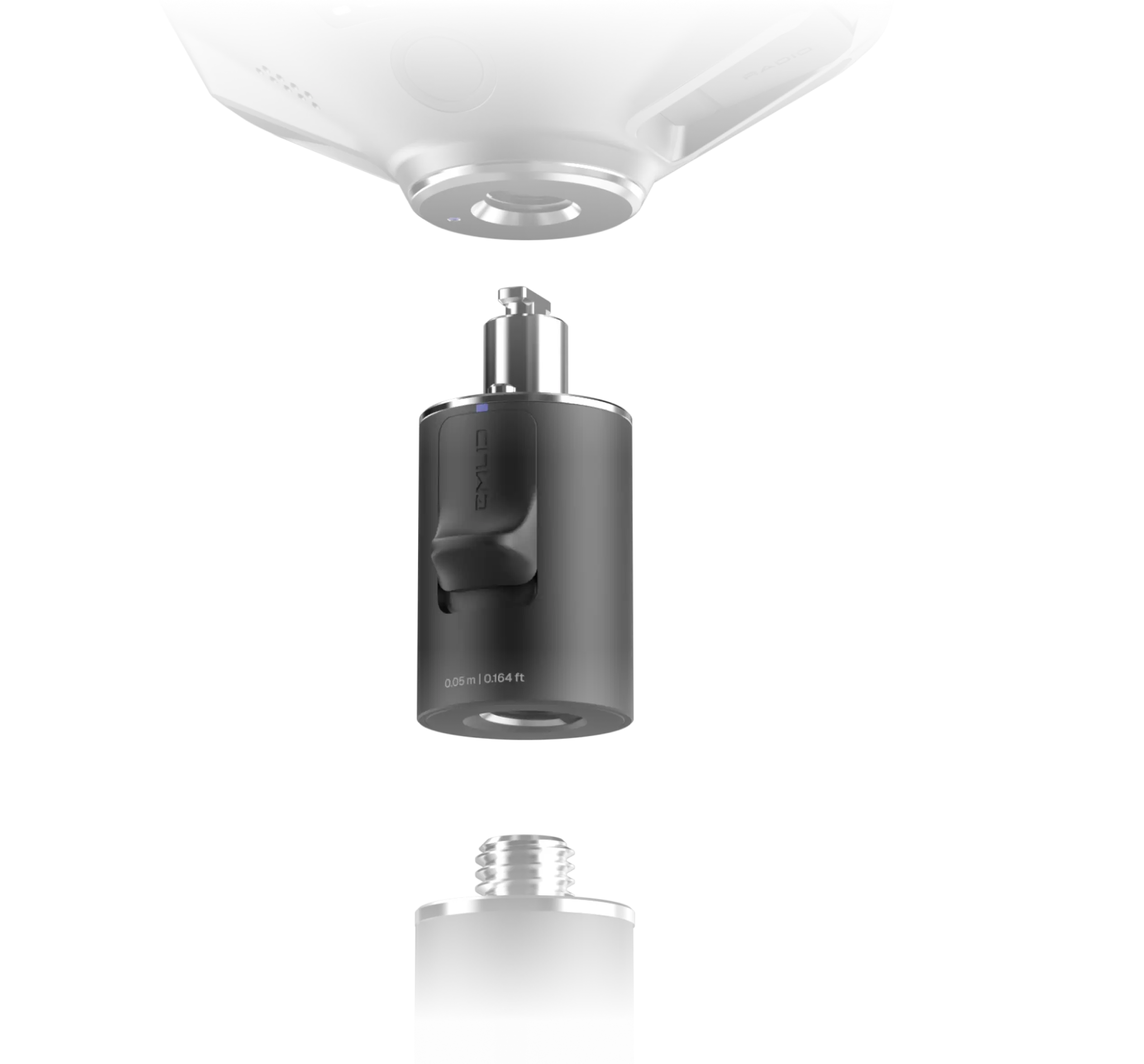
Quick release mount
The custom-designed quick release mount ensures the receiver is locked firmly to your survey pole, eliminating backlash. Even the smallest wobble can affect tilt-based measurements at steeper angles. This mount solves the issue with a fast and rock-solid connection for reliable data accuracy.
Base and rover connectivity
NTRIP
Connect to VRS or single-base CORS networks using RTCM3 format for precise RTK corrections. You can also transmit corrections from your own base using Emlid NTRIP Caster
Dual-band radio
UHF 450 MHz

LoRa 915 MHz
Engineered for the harshest environments
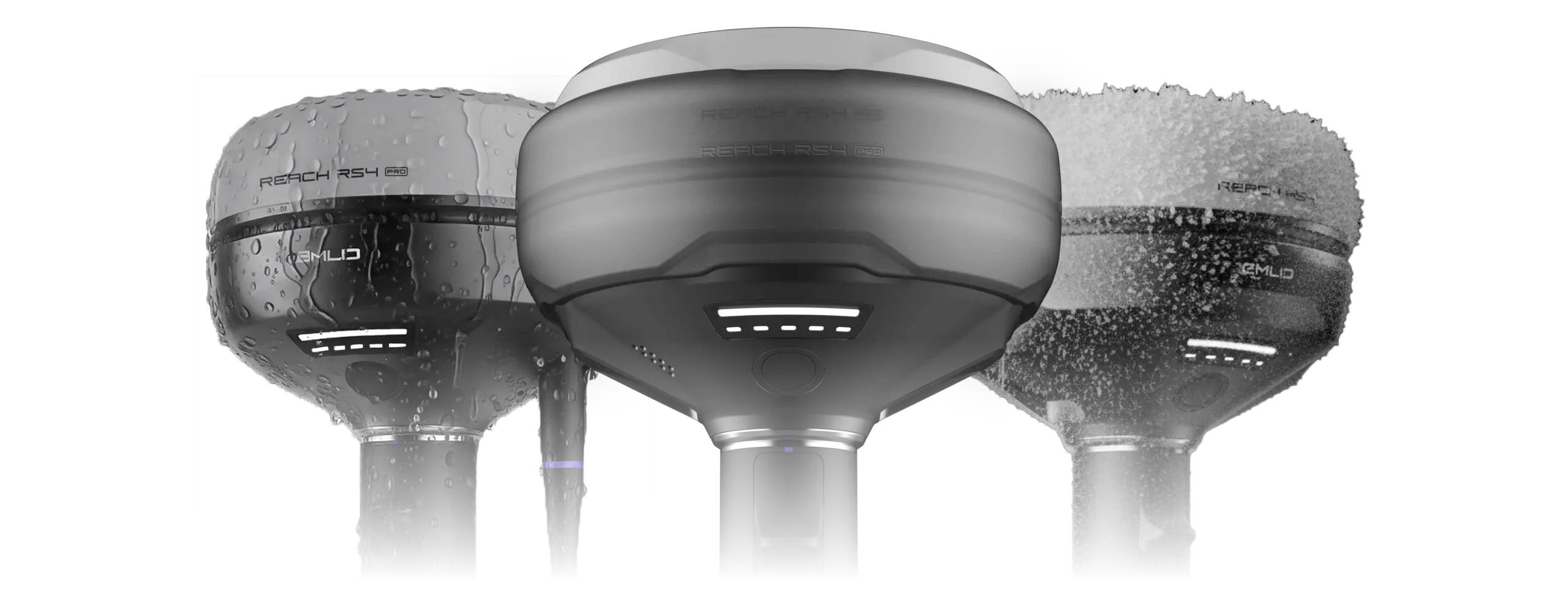

Magnesium alloy body

16 hours on one charge

Waterproof

-40 to +65 ºС
First reviews


Software to drive your entire workflow
The Reach RS4 Pro is powered by Emlid Flow—a complete field and cloud solution for iOS and Android. From initial setup to final verification, Emlid Flow keeps your entire team connected, your data synchronized, and your project on track.
Keep your team in sync


Handle all types of fieldwork


Specification
Mechanical
- Dimensions 128.6 x 128.6 x 99.3 mm
- Weight 920 g
- Operating temperature -40 to +65 °C
- Ingress protection IP68
Electrical
- Autonomy 16 hrs as RTK rover with tilt
-
Battery Li-Ion 5000 mAh, 7.2 V
36 Wh -
Charging USB Type-C (PD): 5V—3A
9V—3A, 12V—3A, 15V—3A
Positioning
-
Static H: 4 mm + 0.5 ppm
V: 8 mm + 1 ppm -
PPK H: 5 mm + 0.5 ppm
V: 10 mm + 1 ppm -
RTK H: 7 mm + 1 ppm
V: 14 mm + 1 ppm - Tilt compensation RTK + 2 mm + 0.3 mm/°
- Convergence time ~5 s typically
Connectivity
-
LoRa radio up to 1W
Frequency range
ㅤ
Power
Distance
868/915 MHz
0.1 W
Up to 8 km UHF radio up to 2WFrequency range
ㅤ
Protocols
Modulation type
410–470 MHz
TRIMTALK 450S**
GMSK -
LTE modem
Regions
Bands Global
FDD-LTE: 1, 2, 3, 4, 5,
7, 8, 12, 13,
18, 19, 20, 26, 28
TD-LTE: 38, 39, 40, 41
UMTS (UHPS/FDD):
1, 2, 5, 8
Quad-band, 850/1900
900/1800 MHz SIM card Nano-SIM -
LTE modem
Regions
Bands Global
FDD-LTE: 1, 2, 3, 4, 5,
7, 8, 12, 13,
18, 19, 20, 26, 28
TD-LTE: 38, 39, 40, 41
UMTS (UHPS/FDD):
1, 2, 5, 8
Quad-band, 850/1900
900/1800 MHz SIM card Nano-SIM - Wi-Fi 802.11a/b/g/n
- Bluetooth 5.1 (BR/EDR + LE)
- Ports RS-232, USB Type-C
- *Use the correct antenna, LoRa or UHF, for your setup. **TRIMTALK is a trademark of Trimble Inc.
Data
- Corrections NTRIP, RTCM3
- Position output NMEA, LLH/XYZ
- Data logging RINEX, NMEA, LLH/XYZ, UBX
- Internal storage 16 GB
Imaging
-
Image sensors 1/2.6 in, CMOS,
global shutter, Full HD -
Field of view
Front camera
Bottom camera H: 64.6°, V: 42.8°
H: 63°, V: 42° - Video frame rate 25 fps
GNSS
-
Signal tracked GPS: L1C/A, L2C, L5,
GLONASS: L1OF, L2OF,
Galileo: E1-B/C, E5a, E6,
BeiDou: B1I, B1C, B2a, B3I,
QZSS: L1C/A, L1C/B11, L2C, L5,
NavIC: L1-SPS Data, L5-SPS - Number of channels 672
- Update rates up to 10 Hz
Free lifetime support

Community

Expert help
Pre-order your Reach RS4 Pro today
Reach RS4 Pro
Reach RS4 Pro, Carrying case, USB-C cable

$4599
Emlid Base and Rover Kit
Reach RS4, Reach RS4 Pro, 2x Quick release adapter, Reach RS4 bumper, Reach RS4 Pro bumper

$8870
Would you like to receive release updates about shipping dates and special offers?
Have a question?
Ask our team
Fill in the contact form, and we will reply within a working day (9:00-18:00 CET).
Direct Dial: +1 817 865 3334 (ex. 101)
Alternatively, you can text us here:
FAQ
What industries and jobs is Reach RS4 Pro best for?
The Reach RS4 Pro is a premium tool manufactured by Emild for land surveyors, construction engineers, critical infrastructure specialists, and drone operators who require highly accurate position data. With advanced GNSS technology, robust antenna, all-band and multi-constellation GNSS support, it can also be used in satellite navigation projects, precision agriculture, mapping, and inspection. The receiver provides an IMU module and a dual camera system to help measure hard-to-reach spots and keep you safe from hazardous areas.
Does Reach RS4 Pro come with a software?
Yes. RS4 Pro integrates seamlessly with Emlid Flow and Emlid Flow 360, powerful software platforms for survey and mapping professionals. Together with the hardware, they provide full control over Reach GNSS systems, base and rover management, correction service configuration, and project setup and data collection. Users also benefit from cloud synchronization, recording data for PPK, and various RTK settings for maximum GNSS performance and precise position.
Can RS4 Pro work as a base station or integrate with other devices?
Absolutely. RS4 Pro can serve as an RTK-GNSS base station, streaming corrections, or it can act as a rover providing position output to external hardware. Its flexible architecture, Bluetooth connectivity, and physical connectors allow smooth integration with autopilots, tractors, GPRs, and industrial monitoring systems. Designed as a multi-constellation, all-band receiver, it is a versatile tool for providing GNSS solutions that can be embedded into familiar workflows and navigation system infrastructures.
How does RS4 Pro ensure durability, safety, and long-term reliability?
The RS4 Pro is built with a rugged, IP68-rated, weatherproof enclosure that protects the antenna, IMU module, and overall system in all working conditions. Its interference mitigation features ensure stable data collection even near a power tower or in dense urban environments ensuring accurate position. The built-in battery has a lifespan of up to two working days before it needs to be recharged.
Performance in the field and is backed by responsive technical support from the manufacturer, ensuring long-term reliability and confidence in daily operations.
What level of accuracy does Reach RS4 Pro provide?
The RS4 Pro delivers RTK accuracy with centimeter precision. Its advanced sensor integration, robust antenna, and optimized band GNSS processing give users a stable position. The RS4 Pro provides consistency across projects, whether using RTK corrections (including SBAS), or PPK workflows.
Dedicated technical support from the manufacturer ensures smooth deployment and long-term reliability.
1 – The formula is RTK + 2 mm + 0.3 mm/°, where RTK is 7 mm + 1 ppm. Therefore, with a baseline of 1 km, the formula becomes 7 mm + 1 mm + 0.3 mm × 30° = 18 mm
2 - UHF radio supports transmission power up to 2 W. The exact allowable power level depends on local country regulations, and in many cases, may require a license. LoRa radio supports transmission power up to 1 W. The maximum output also varies by country, but LoRa is optimized to remain within license-free limits in most regions.
3 – TRIMTALK is a trademark of Trimble Inc.