
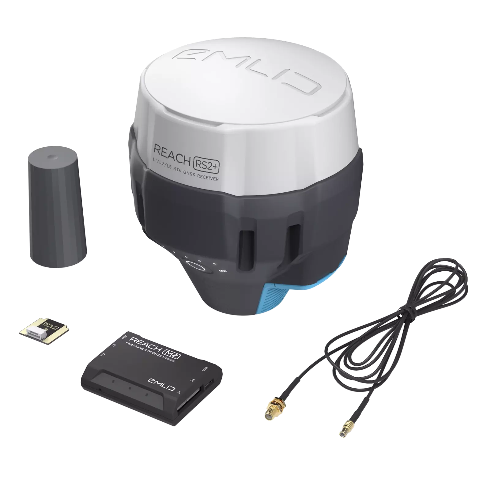
REACH M2
RTK GNSS module
for UAV mapping
Positioning with centimeter accuracy
in RTK and PPK. For precise UAV
mapping with less GCPs.
Multi-band.
Baseline up to 100 km in PPK.
$649
Buy
PPK mapping with centimeter accuracy. Use fewer GCPs
Why camera synchronization is so important?
Usually autopilot triggers the camera and records the coordinate it has at that moment. When the drone is flying at 20 m/s and GPS works at 5 Hz, that means your autopilot will have position readings only each 4 m, which is not suitable for precise georeferencing. In addition, there is always a delay between the trigger and the actual moment the photo is taken.
Reach eliminates the delay
Reach solves the problem of positioning by connecting directly to the camera hot shoe port, which is synced with the shutter. The time and coordinates of each photo are logged with a resolution of less than a microsecond. This method allows GCPs to be used only to check your accuracy.
1.
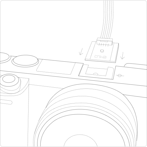
Connect Reach to a hot shoe port on a camera
Every time a photo is taken camera produces a pulse on a flash hot-shoe connector which is synced to a shutter opening.
2.
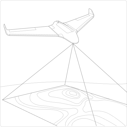
Fly a drone, Reach will record photo events
Reach captures flash sync pulses with sub-microsecond resolution and stores them in a raw data RINEX log in the internal memory.
3.
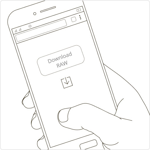
Download logs from Reach and base station
After the flight, get the RINEX logs from your airborne Reach module and a base station (Reach RS, CORS or another receiver).
4.
Process logs and get a file with geotags of photos
Process RINEX files using free RTKLIB software. The produced file with precise coordinates of the photos can be used for georeferencing.
NTRIP or another Reach as a base station
To calculate centimeter-precise coordinates in PPK and RTK, Reach needs corrections from a base station. It could be either another Reach receiver or an NTRIP service. VRS is also supported.
Compatibility
Reach M2 works seamlessly with other Reach receivers over any link and are compatible with any other receiver that supports RTCM3 and NTRIP.

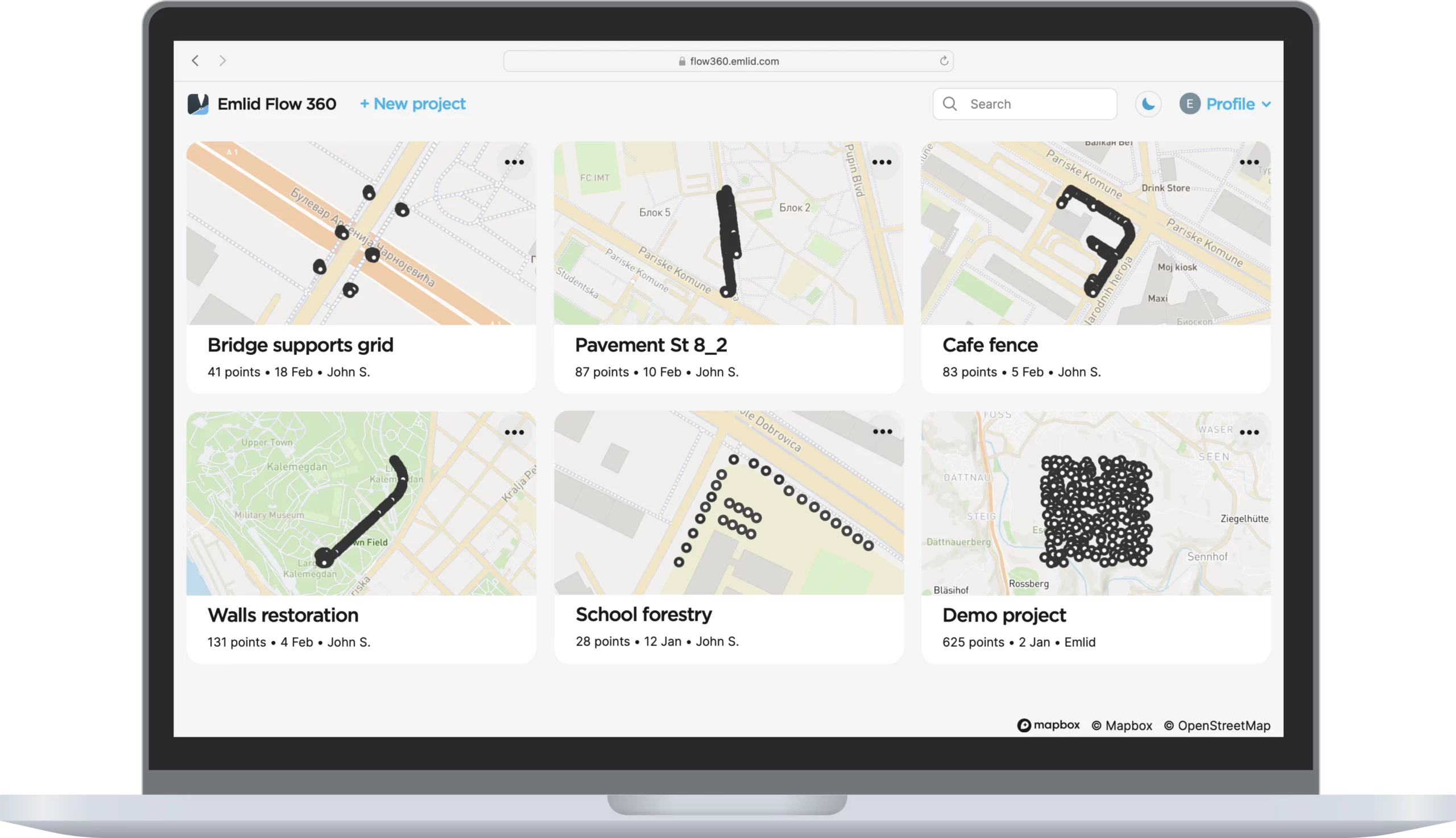
Comes with the Emlid Flow app
and cloud-based service Emlid Flow 360
Emlid Flow is a mobile app for iOS and Android. The app handles all the fieldwork—receiver settings and data collection. All survey data is in sync with cloud-based service Emlid Flow 360, which allows you to access your projects from the browser and manage survey data.
Logging
in RINEX
Logs are automatically recorded in the RINEX format for further post-processing. View a list of the logs and download them using the Emlid Flow app.
For PPK, you can use our free software Emlid Studio.
Data
monitoring
Emlid Flow shows current satellite levels and your location on a map. It allows you to easily access full information about the receiver: battery charge, type of Internet connection, and receiver solution status.
Work with different background maps
Upload topographic maps, cadastral plans, and aerial imagery from WMS and WMTS sources or work with a built-in satellite map.
Managing projects in the cloud
The Emlid Flow app is synchronized with the Emlid Flow 360 service. This allows you to create and access survey projects, manage coordinate systems, and export and import data using both the mobile app and the cloud service at flow360.emlid.com.
Reach in action
3DroneMapping completes PPK trials with the average zero mean error in all axes
Luke Wijnberg, 3DroneMapping
As a brief synopsis of the results, the maximum deviation of points was no more than 0.09m in all axes. This is an incredible result given the fact that the average pixel size of the resulting imagery was 0.045m. The average mean error in all axes is just few mm!
Tuffwing gets 4cm precision without GCPs with Emlid Reach RTK
Brian Christal, Tuffwing
Tuffwing recently performed integration of Emlid Reach RTK to enable precision maps to be made without the use of GCPs. The system has been benchmarked by comparing a direct georeferenced model with a set of GCPs, used solely for error detection purposes. The lateral RMS error achieved is just 4cm according to the Pix4D quality report.
Evеnt38 integrates Emlid Reach and starts providing a ready-to-go PPK mapping solution
Jeff Taylor, Event38
In this case study, we produced an orthomosaic in the Drone Data Management System™ with 2.45cm horizontal and 5.08cm vertical RMSE, as compared with a survey-grade GPS on the ground.
Reach
in the Emlid Store
The basic features of Emlid Flow are available for free to all Emlid users.

Shipping from Chicago
2-3 days by USPS Priority Mail Express
2-7 days by FedEx, UPS
Specification
622 kb
Mechanical
- Dimensions 56.4 x 45.3 x 14.6 mm
- Weight 35 g
- Operating tº -20 to +65 ºC
Electrical
-
Power supply voltage on
USB or JST-GH connectors 4.75 - 5.5 V - Antenna DC bias 3.3 V
- Typical current consumption @5V 300 mA
Positioning
- Static horizontal 4 mm + 0.5 ppm
- Static vertical 8 mm + 1 ppm
- Kinematic horizontal 7 mm + 1 ppm
- Kinematic vertical 14 mm + 1 ppm
Connectivity
- LoRa radio (sold separately)
- Frequency range 868/915 MHz
- Distance Up to 8 km
- Wi-Fi 802.11 b/g/n
- Bluetooth 4.0/2.1 EDR
- Ports USB, UART, Event
Data
- Corrections NTRIP, VRS, RTCM3
- Position output NMEA, LLH/XYZ
-
Data logging
RINEX with events
with update rate up to 10 Hz - Internal storage 16 GB
GNSS
-
Signal tracked
GPS/QZSS L1C/A, L2C
GLONASS L1OF, L2OF
BeiDou B1I, B2I
Galileo E1B/C, E5b - Number of channels 184
- Update rates 10 Hz GNSS
Have a question?
Ask our team
Email us at sales@emlid.com or fill in the contact form. Our application engineers will reply to you within a working day
(9:00-18:00 CET).

Direct Dial: +1 817 865 3334 (ex. 101)